Biography
Currently, I work as a Postdoc with Prof. Manoochehr Shirzaei within the EOI lab in the Department of Geosciences at Virginia Tech. My research focuses on the modeling and projecting land subsidence using deep learning. During my phd studies, I work with Prof. Hua Zhang at the WESA Lab. My study focuses on an innovative analysis of land subsidence and its potential impact on water infrastructure as well as thereafter flood risk. During my master period, I work with Prof. Tingjun Zhang and focused on the investigation of permafrost deformation using terrestrial LiDAR and UAV technologies. Overall, my research focuses on land subsidence analysis (InSAR, LiDAR, UAS photogrammetry), deep learning, and flooding analysis.
I obtained PhD degree in Geospatial Computer Science from Texas A&M University-Corpus Christi in May 2024, as well as bachelor and master degree in Geographic Information Science from Lanzhou University in June 2016 and 2019, respectively.
Research
-
 RSE
RSE
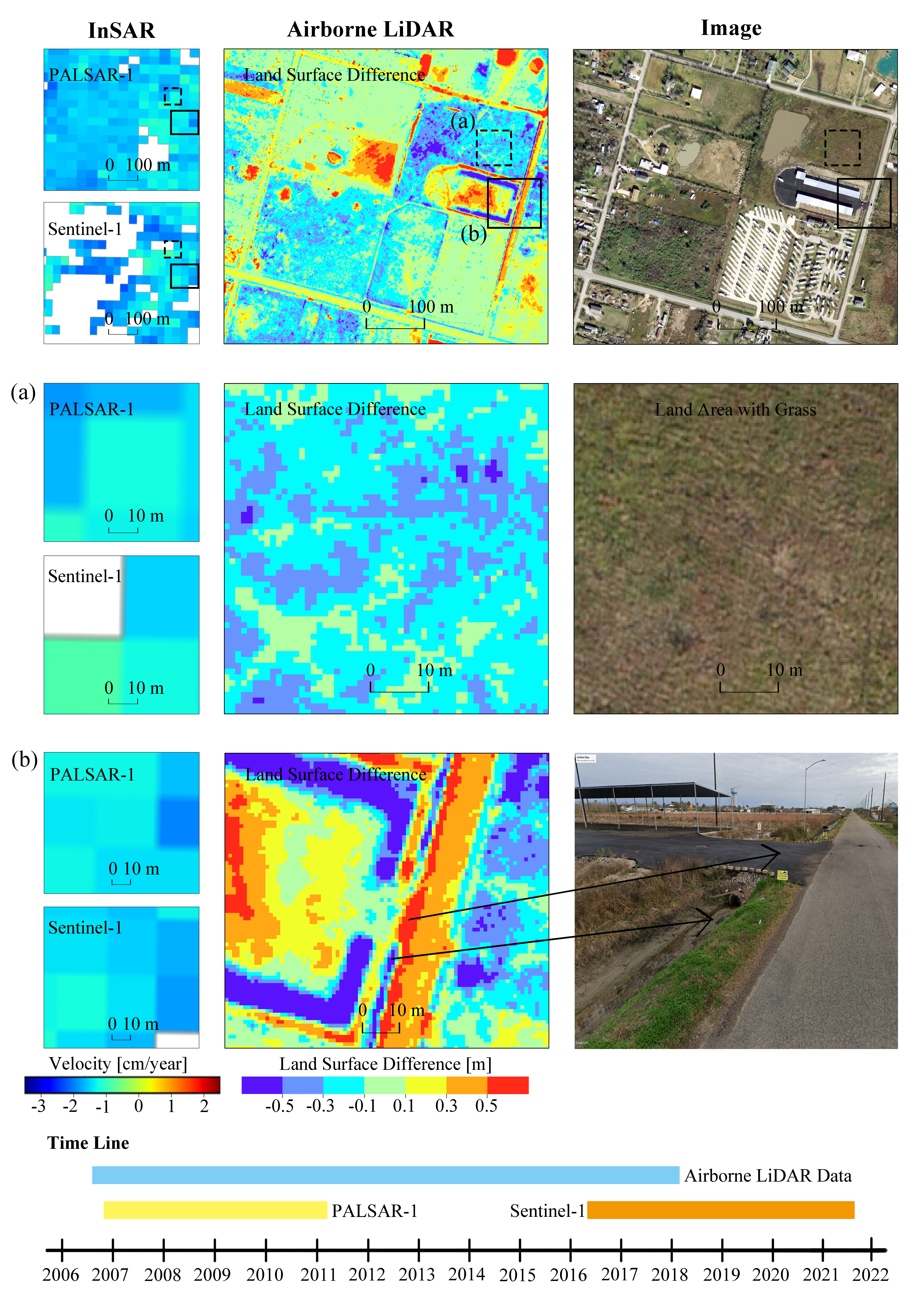
This study first attempts to integrate InSAR and airborne LiDAR methods to investigate the spatiotemporal pattern of coastal subsidence. By examining and comparing about 30-m InSAR results and 1-m airborne LiDAR results, this study found that, over the highly subsided area, airborne LiDAR could complement InSAR results by shedding light on the subpixel variations of InSAR results, identifying significant surface changes that InSAR cannot capture and potentially understanding the subsidnece during the gap years between two InSAR analysis.
-
 JAG
JAG
With seven terrestrial LiDAR datasets collected from April 11, 2016 to June 16, 2018, we revealed that thermokarst landforms in our study site developed consistently with seasonal ground temperature change and were triggered significantly by extreme precipitation events. Particularly, the vertical deformation and headwall retreat of thermokarst landforms reached −3.364 m and 10.66 m during the monitoring period, respectively.
-
Zhong W, Chu T, Tissot P, Wu Z, Chen J, Zhang H. (2022). Integrated coastal subsidence analysis using InSAR, LiDAR, and land cover data. Remote Sensing of Environment, 282, 113297.
-
Zhong W, Zhang T, Chen J, Shang J, Wang S, Mu C, Fan C. (2021). Seasonal deformation monitoring over thermokarst landforms using terrestrial laser scanning in Northeastern Qinghai-Tibetan Plateau. International Journal of Applied Earth Observation and Geoinformation, 103, 102501.
-
Zhong W, Nian Y, Pan X, Wang Y. (2015). Landslide monitoring analysis based on 3D laser scanning: a case study of Fulongping and Hongshangen landslides in Lanzhou. Journal of Lanzhou University (Natural Sciences), 06. (In Chinese)
-
Jia L, Fan C, Mu M, Chen X, Zhong W, Shang J, Zhang F, Li L, Peng X, Mu C, Zhang T. (2020). Studies of thermokarst and its effects on ecosystem carbon cycle in the Third Polar regions and the Arctic. Journal of Glaciology and Geocryology, 42(1), 157-169. (In Chinese)
-
Mu C, Shang J, Zhang T, Fan C, Wang S, Peng X, Zhong W, Zhang F, Mu M, Jia L. (2020). Acceleration of thaw slump during 1997–2017 in the Qilian Mountains of the northern Qinghai-Tibetan plateau. Landslides, 17(5), 1051-1062.
-
Shang J, Zhang T, Gao T, Mu C, Wang S, Fan C, Zhong W. (2019). Characteristics of thaw slumps over Eboling areas in Qilian Mountains using remote sensing data. Quaternary Sciences, 39(5), 1203-1210. (In Chinese)
-
Mu C, Wu X, Zhao Q, Smoak J. M, Yang Y, Hu L, Zhong W, Liu G, Xu H, Zhang T. (2017). Relict mountain permafrost area (Loess Plateau, China) exhibits high ecosystem respiration rates and accelerating rates in response to warming. Journal of Geophysical Research: Biogeosciences, 122(10), 2580-2592.
-
Mu C, Zhang T, Zhao Q, Guo H, Zhong W, Su H, Wu Q. (2016). Soil organic carbon stabilization by iron in permafrost regions of the Qinghai‐Tibet Plateau. Geophysical Research Letters, 43(19), 10-286.
News
Contact
Address: Blacksburg, VA, USA
Email: wenzhong24@vt.edu
Last Update: